 MONITORING TOOL
Guidelines for early warning indicators of regime shifts
TO WHOM IS ADDRESSED?
Marine Protected Area (MPA) managers, researchers, scientistsTHEME
Climate change, MPA managementKEYWORDS
Climate change, early warning, environmental quality, regime shift, resilience, stability
WHAT PROBLEM WOULD THIS SOLVE?
The tool consists of implementing a simple protocol to obtain early warning indicators of a regime shift or collapse of marine forests, including macroalgal canopies and seagrass meadows. This requires monitoring the spread of algal turfs, low-lying (usually filamentous) algae at the edge of marine forests. A healthy forest provides a barrier against the invasion of algal turfs, which provide a less productive and usually species-depauperate alternative state. The more algal turfs spread into the forest, the greater the risk of collapse.
Aim of the tool
This tool aims to provide guidelines for monitoring early warning indicators of regime shifts or collapsing marine forests.
Main objectives
The objective of the tool is to provide a protocol to obtain early warning indicators of a regime shift or collapse of marine forests, including macroalgal canopies and seagrass meadows.

WHAT IS NEEDED FOR IMPLEMENTATION?
Technological infrastructure
Spreadsheet software
Training
A minimum of training is required for MPA staff in charge of establishing the permanent transects and for those involved in experimental validation. Personnel need to be trained in field measurements and sample algal turfs with visual methods (e.g., photographic) and data entering into spreadsheets.
Investment
Costs will vary according to the site. Investments are needed for: a training workshop directed to MPA staff, which could be planned within AMARE plus; a field-based demonstration to ensure the efficient and correct implementation of the methodology; and personnel and field equipment costs.

HOW TO USE IT?
Concept
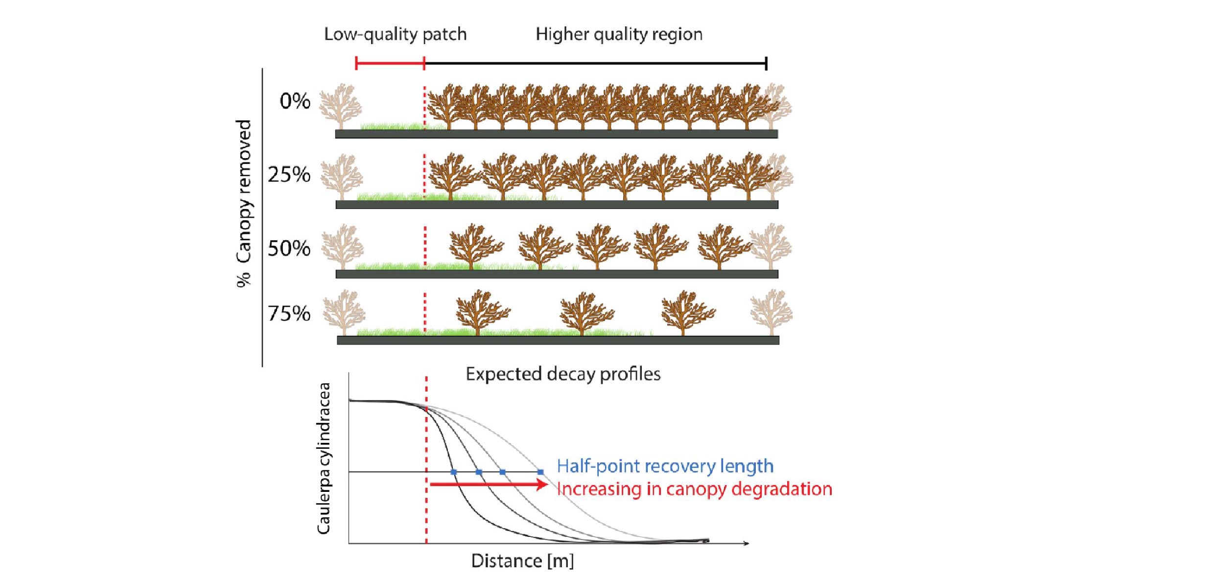
The early warning system consists of establishing permanent transects at the edge between a forested patch and an area colonised by algal turfs. The abundance (percent cover) of algal turfs will be monitored just outside the canopy and 1-1.5 m within the forested patch. The indicator, called the recovery length, is quantified as the distance at which the cover of algal turfs will be reduced to 50% of that observed in a plot just outside the canopy. Large values of the indicator correspond to a larger penetration of algal turf inside the macroalgal forest or the seagrass meadow. When implementing the recovery length in a new area, it is recommended to perform a preliminary small-scale thinning experiment to ensure that the system behaves as expected and that algal turfs expand upon canopy removal. Probing the recovery length allows establishing the early warning system on the basis of observations alone, without any additional manipulation. Several transects can be established in an area and sampling can be done yearly or more frequently if necessary.
Pilot areas
Secche Della Meloria MPA (SIC/ZSC), Tuscany, Italy
Implementation Dates
Establish at least five replicate 1.5 m transects at the border of each focal macroalgal forest or seagrass meadow and sample the transect once a year at the peak of vegetative cover of algal turfs, usually in summer.

WHAT CHALLENGES MAY ARISE?
Implementing the tool is simple after a minimum of training. Data analysis to quantify the recovery length is more complicated, but personnel involved in AMARE Plus will help.

WHAT ARE THE EXPECTED RESULTS?
Quantitative results
The ability to quantify and clearly communicate the health status of key marine coastal ecosystems, such as macroalgal forests and seagrass meadows.
Key deliverables
Demonstration activity, reports, web-based communication tools.
Transfer potential
The proposed tool can be immediately implemented in MPAs, but we recommend having additional experimental tests assess the generality of its assumptions in a sample of locations.
Pilot areas
Secche Della Meloria MPA (SIC/ZSC), Tuscany, Italy
KEY INFORMATION
The proposed tool originates from a robust theory on the dynamical behaviour of complex systems.
There are a number of key papers defining the proposed indicator and its implementation under controlled laboratory conditions and in more complex real-world systems:
- Dai, L., Korolev, K. S. & Gore, J. Slower recovery in space before collapse of connected populations. Nature 496, 355-358, doi:10.1038/nature12071 (2013).
- Rindi, L., Dal Bello, M., Dai, L., Gore, F., Benedetti-Cecchi, L. 2017. Direct observation of increasing recovery length before collapse of a marine benthic ecosystem. Nature Ecology and Evolution. doi:10.1038/s41559-017-0153.
- Rindi, L., M. Dal Bello, and L. Benedetti-Cecchi. 2018. Experimental evidence of spatial signatures of approaching regime shifts in macroalgal canopies. Ecology 99:1709-1715.

The recovery length in the figure above, quantifies the propagation of a perturbation in space. In the figure, algal turfs propagate from a low-quality patch into a macroalgal forest. The larger the propagation, the closer the proximity of the forest to a point of collapse. The indicator is the distance at which the algal turfs decline to 50% of their abundance in the low-quality patch. This is called the half-point recovery length. An experimental test of the indicator is recommended before establishing the monitoring tool in a new area.
For further information
Project name: AMARe
Lisandro Benedetti-Cecchi, Department of Biology, University of Pisa lbenedetti@biologia.unipi.it
Links of interest
https://www.quantamagazine.org/critical-slowing-warns-of-looming-disasters-20151118
Partners
- Corsican Agency for Environment (OEC)
- Euro-Mediterranean Centre on Climate Change – CMCC
- French Research Institute for Exploitation of the Sea, Department of Oceanography and Ecosystem Dynamics (IFREMER)
- Hellenic Centre for Marine Research
- Management Body of The National Marine Park of Alonissos Northern Sporades
- Management Consortium of Torre Guaceto
- National Research Council, Institute of Marine Science – CNR-ISMAR
- Regional Government of the Balearic Islands – Department of Environment, Agriculture and Fisheries
- Spanish National Research Council (CSIC)
- University of Malta


